Molise landslide, caused by extreme weather, severs road and rail links along the southern Adriatic corridor. Authorities warn repairs could take months.
Prime Minister Giorgia Meloni convened an emergency videoconference on Wednesday with senior ministers and civil protection chiefs after a historic landslide in Molise reactivated overnight. It blocked the A14 motorway, the SS16 Adriatica state road, and the Adriatic railway line, effectively cutting Italy in two along one of its most critical north-south corridors.
Attending the meeting were Infrastructure and Transport Minister Matteo Salvini, Defence Minister Guido Crosetto, Civil Protection chief Fabio Ciciliano, and Cabinet Secretary Alfredo Mantovano. The night before, Meloni had personally telephoned Francesco Roberti, president of the Molise Regional Council, as the scale of the crisis became clear. Technical inspections are now underway at the Petacciato landslide site to assess the damage and evaluate what interventions may be possible to restore access.
One of Europe’s largest landslide fronts
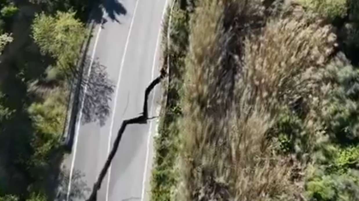
The Petacciato landslide front is considered one of the largest in Europe. The landslide reawakened after eleven years, sending the Adriatic coast into chaos, triggered by extreme rainfall of over 200 millimetres in just a few days.
According to technicians from the Molise region, at the root of the phenomenon is a deep, water-saturated fault running through the area’s subsoil — a clayey mass sliding over less stable layers, fed by underground water flows. A monitoring system had been active in the area for some time, consisting of sensors on the infrastructure and on the ground itself, and it was this system that triggered the alarm leading to the closure of the road.
At least fifteen landslides were recorded at Petacciato between 1906 and 2015.
Weeks or months to repair
The assessment from authorities has been blunt. Civil Protection chief Fabio Ciciliano said the situation is “very complex” and will take weeks, if not months, to resolve. “We’re talking about a landslide front four kilometres long, and the railway line passes through it. Until it stops moving, it won’t be possible to carry out any type of infrastructure repair.”
The railway tracks have already deformed by around ten centimetres due to the ground movement. High-speed trains on the Adriatic line have been halted entirely, with services diverted via Caserta and Rome. Over a thousand passengers were stranded at Vasto-San Salvo station after the Adriatic line was suspended.
The road situation is no less severe. Traffic jams of up to thirteen kilometres formed as vehicles sought alternative routes. Civil Protection is considering loading heavy goods vehicles onto ships, as there is no viable alternative road network capable of handling the volume of freight traffic.
A compounding disaster
The Petacciato reactivation has struck at a moment when the region was already severely weakened. The collapse of a bridge over the Trigno river had already blocked the SS16 Adriatica at the Abruzzo-Molise border. This means there is now no functional alternative route. One motorist remains missing following that collapse.
The mayor of Petacciato, Antonio Di Pardo, described the town as completely isolated with all access routes cut off. He added that families are being evacuated as the clayey subsoil beneath residential properties has begun to move. Molise’s regional president Roberti described the crisis as not merely a regional emergency but a national one. Italy is divided along its main Adriatic artery, people and goods cannot move freely between north and south.
Schools across the province of Campobasso were closed on Wednesday. The prefect cited severe traffic disruption and the need to reduce vehicles on already overwhelmed roads.
A region under chronic pressure
The crisis has renewed scrutiny of Italy’s long-standing hydrogeological vulnerability. Italy’s national geological risk mapping body, ISPRA, has recorded more than 23,000 land movements across Molise. Areas classified as very high risk cover over 225 square kilometres of the region, some 16% of its total territory.
Critics have pointed to bureaucratic delays and stalled funding. A hydrogeological consolidation project worth over 40 million euros was announced by the Molise region back in 2021, but construction work has yet to begin.
With the Molise landslide still moving and no timeline for stabilisation, the focus now turns to emergency logistics and the welfare of displaced residents.
Sources: Palazzo Chigi; ANSA; Il Sole 24 Ore; La Repubblica; Quotidiano.net; Blue News


